JMT 2011 - Trip Report
Sep 05, 2011
Days 1-3, Yosemite to Deer Crossing via Reds Meadow
Day 1
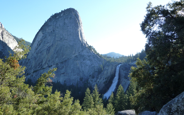
I set off from the Backpackers campground at 6.15am (first light around 6.00am) and took the ten minute walk to the beginning of the trail, expecting to be largely alone, in fact there were lots of walkers up and around and setting off for the ascent of Half Dome. Almost without exception the path of the JMT is well presented, and in Yosemite it's wide and well travelled, travelling East you gain height through the forested granite catching glimpses of Nevada Falls as the sun rises ahead. The ascent is gradual which makes for easy walking and after a few hours you cross the top of the falls and continue on to Half Dome junction.
The JMT trail is coincident with the tourist route up Half Dome until 'Half Dome Junction' where the trails split. My guidebook suggests making the ascent of Half Dome then doubling back to the junction before camping a bit further on up the trail. In fact on the day I arrived the Half Dome route was closed due to a fatality the previous evening and it would only open again when the body was found - I therefore skipped it and headed on to the end of guidebook 'Day 2' at Sunrise High Sierra Camp. The route continues up from Half Dome junction, breaking out of the woodland now and again to reveal magnificent views across the valley, eventually levelling off on the approach to a wide, flat meadow. A short distance across this, on the left, is Sunrise Hgh Sierra camp, a collection of 'tent cabins' and a rocky area set aside for backpackers to camp.
The decision not to wait for Half Dome to 'open' resulted in a long day of ascent, 13.5 miles, 10 hours and 5750ft of ascent. I arrived at the camp about 4.15pm with two companions I had met on the way up. The evening was characterised by mosquitos! I had packed a headnet which became invaluable in the early stages of the trip, the Americans were also armed with DEET preparations which I later procured for myself in an effort to stem the onslaught. Wearing thin lightweight clothing was no protection and by Day 2 I was covered in bites, especially on my face, hands and legs. The heat of the day gave way to the cool of the night and it was dark by 8.30, and I was asleep shortly after.

Day 2
The next day I was on the trail by 6.30am, predominantly downhill today the walking was very pleasant - predominantly through woodland. Less than an hour out from camp there are superb views across to Cathedral Peak and Columbia Finger before the descent to Tuolumne Meadows begins. You don't have to backpack this route - there are organisations that arrange for supplies to be taken ahead so that allyou need is a small daypack. The favoured method of transporting goods olong the trail is by mule, and I passed a number fo mule trains on my journey south.
I arrived at Tuolumne Meadows around 11.00am, this is the first and last road to be encoutered on the trail, the guidebook points to a Post Office, Shop, Restuarant and other facilities, it doesn't mention that these are all contained within one TENT! - I stopped for a soft drink then headed off up Lyell Canyon - a few hours of level walking along a the right bank of the river and I arrived at a place to camp. With your wilderness pass you can camp virtually anywhere along the route, but there are also recognised campgrounds where people generally congregate - its up to you whether you want to use these or avoid them. I was about a mile short of the first regular camping place and decided to stop, firstly I'd found an excellent place, and secondly I was tiring - it was about 4pm. The campsite had attracted me because there was a slight breeze that would keep the mosquitos at bay, which it did when it was blowing but not when it didn't! I managed to get a meal cooked then retired to the tent, relaxed with my iPod and settled down for the night - elevation 8540ft. Woke at 3.30 am by shouting and banging of pots from up the valley, this went on for over an hour.
Day 3
The next morning I had the opportunity to quiz the campers up the valley, they had lost touch with one of their party who had one of the 'Bear Barrels', this meant they couldn’t get all their food stored into their remaining one – so they’d hung the excess food from a tree. A bear turned up to claim the food and they had to chase it away – which took a long time. Its now mandatory to carry bear proof food containers (Bear Barrels) along the JMT, previous practice of hanging food no longer works, bears are wise to it and are able to obtain the food protected in this way - as these campers found out. The Rangers would say ‘I told you so’ and they take a dim view of such incidents. The onus is on the camper to ensure a bear does not successfully get their food, if a bear is successful it will try again and the Rangers will eventually shoot it out of necessity – ‘protect your food and save a bear’ is the mantra at Yosemite valley.
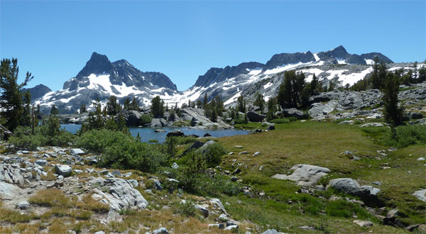
I climbed steadily out of the canyon up to Donohue Pass - the first of the passes on the JMT. It was a relief to get above the treeline - the views back down Lyell Canyon were exceptional. Almost at the top there was a bit of snow to be negotiated - it was soft and raltively level - so no problem. Met up with three others who would be my companions over the next few days. Across the pass the trail continues through some spectacular scenery to Thousand Island Lake. Clear skies and high temperatures were taking their toll - at lunchtime we stopped by a fast flowing stream and cooled down. I was establishing my hydration routine, constantly sipping water from my 2L bladder supplemented by half a litre of Nuun electrolyte at lunchtime and just after the evening halt.
Although the trail is hot and dusty water is plentiful, with little need to carry more than a litre and a half at any one time. I was feeling drained so cooked up some flavoured cous cous for lunch - it was good move - cous cous is the ideal food for backpacking - I only wish I liked it! My companions were determned to reach Reds Meadow by the following day and pushed on in the hot sun. By the time we reached Garnett Lake I was ready to stop again, but after a short rest we ventured on round the xxxern end and across the outlet to the soutehrn shore. There was some camping here but most positions were taken so we ventured up the other side, eventually stopping a few miles short of Shadow Lake. The mosquito count was relatively low and we enjoyed a relaxed meal and examined the differences between US and UK cultures!
Day 4
Managed to get a cell phone signal for the first time on the trail - spent quite a while on the phone, set off arond 7.30am. The walking today was mainly forest trail. Just before Reds Meadow we passed by the Devil's Postpile - naturally occuring exposed basalt columns are an impressive sight. Arrived at Reds Meadow around 1pm, shunned a beer but tucked into salad and a burger - regretted it instantly - I obviously wasn't ready for modern convenience food and hit the trail quickly after saying goodbye to my companions who were off home from Reds.
Reds is a 'guidebook overnight' and/or a re-supply station - but I used it as neither, I hadn't been on the trail long enough to appreciate it. The guidebook sugegsted 9 days to Vermillion Valley Resort (VVR), but I knew I could get some food on the way, so I started with food for 6 days. I had saved a day by missing Half Dome and was averaging about 1.5 guidebook days for every actual days walk, so it looked like I wasn't going to need to supplement the food I had.
After leaving Reds the trail threads through a fire-decimated area before disappearing once again into thick woodland. I finally arrived at Deer Crossing at 6pm, its an inconspicuous river crossing in thick woodland and when I arrived it was raining. The tent went up very quickly, I grabbed the water I needed and I did everything from inside the tent, ate, drank, washed, treated my feet, listened to music and fell asleep.
Days 5-9, Deer Creek to Le Conte Canyon.
Day 5
More forest trail today for a time until the route breaks out into higher ground at Purple Lake and then the much higher Victoria Lake. Weather today carried on from previous night - intermittent showers - but by the time I reached Victoria Lake it had turned into hailstones - big and hard ones - bizarre indeed.
Chomped my way through cereal bars and nut mix. Back into the woods and my guidebook urges me to camp in a popular spot overlooking a creek in a small clearing. I only stop to rest and am assaulted by mosquitos - this makes the undesirable camp unbearable - I had always intended moving further on - trying to get close to Vermillion Valley Resort (VVR) for my rest day.
From the suggested campsite the trail rises over the next hour or so out of the narrow wooded valley and onto a highspot at Squaw Lake - which is beautiful and subject to a healthy breeze. My plan had been to carry on over Silver Pass to get me within hiking distance of the morning ferry which sailed at 9.30am.
I met Gerrard at Squaw Lake - and another couple setting up camp - I'd learned on other trips that if you find an ideal campsite - use it - even if its not quite as far as you wanted to go. I made a quick calculation, by setting off an hour before sunrise I could still make the ferry if I camped here. I scouted the route to Silver Pass that I would need to take in the dark - the path was well trodden and I thought it would be clearly visible by artificial light.
That settled I set up camp and cooked a very nice meal in great comfort - had a good wash, shave and felt at peace with the world! Spent some time chatting with my companions before retiring to the tent - virtually mosquito free.
Day 6
I woke with my alarm at 4.30am - packed up and away by 5 - stunned by the starscape above my head. One of the benefits of a relaxed camp the previous night was that I was able to setup for a fast getaway.
Keeping my gear light and walking in summer caused me to bring only an Inova Microlight as my only directional light - a powerful headlamp would have been more appropriate but its a testament to this little powerhouse that it was sufficiently bright to illuminate the path ahead.
I arrived at Silver Pass just as dawn was breaking and packed away my light, the mountains were particularly striking in the halflight. All downhill from here to the ferry! The initial descent is easy walking over high mountain granite and you gradually arrive at a steep section which is descended in zig zags. The views of the rocky slabs to the left are awesome, you are very high, and the mountainside is very steep. Monitoring my progress all the time I could see that I was on target to meet the 9.30 ferry, at about 8.30 I crossed an innocuous stream, slipped and fell in up to my waist. Still calculating that I had only just enough time I ignored my wet condition and pressed on - reaching the ferry landing in a considerably worse state than other people there!
On arrival at VVR I had breakfast immediately, coffee, bacon and fried eggs - hmm! There are various accommodation options at VVR, you can camp or share a tent cabin - I was after some luxury so I hired a trailer for the night - this meant I had my own space, own shower and own toilet.

Day 7
I love this point in a walk - I'd had about a week to lose some weight and improve my fitness, my body was acclimatised to the altitude and I was coming off a rest day - there's no better feeling of contentment! I left VVR on the ferry at 9.20am and after a brief visit to the Osprey nest on the side of the lake I was walking again by 10.00am. The climb onto Bear Ridge today is billed as a bit of a slog - but feeling as I did I enjoyed it, and as with all of the JMT the steep inclines are negotiated with relatively easy zigzags. Much of the ascent is in the forest but eventually breaks out to reveal some nice mountain views across the valley. The suggested campsite is a relatively low altitude Rosemarie Meadows, and most of the hikers from VVR were aiming to go further, to Marie Lake - a large irregular lake sitting in granite bowl, an ideal camping area. I arrived a little early so continued on over Seldon Pass - stunning view at the top by the way, looking down the narrow valley - I carried on down to Sallie Keyes Lakes. The trail passes between these two lakes across a wooded strip of land - it looked like a mosquito magnet to me so I collected water and backtracked a quarter mile to a perfect spot I'd noted as I'd passed.
Day 8
The route continues down into forest and zigzags down a long steep slope to a junction, I left the trail here to trek for for a short section through woods to the Muir Trail Ranch. My guidebook says 'not very friendly', I would say 'businesslike'. Those hikers wishing to pick up their bucket of supplies are kept away from paying guests and although I knew the answer before asking I enquired about using the loo. Hmm!
I also enquired about the appeal of Soda Springs - a few hours detour could see me bathing in a hot spring - a 'must see' according to the guidebook, my chaperone on the ground said 'there's a pool next to the spring and the waters a bit tepid, you can get in it if you like'.
I shouldered the extra weight of eight days food and picked my way back to the official JMT route. A long stretch of further forest walking brought me too a steep ascent up to a high mountain meadow. Once the required height was attained there was the river to cross - the only major crossing I faced - thigh deep water was straightforward to cross even if getting swept away would have meant certain death over s ateep waterfall.
By 4.30 I'd reached McClure Meadow - a stunning expanse of riverbank with a stunning mountain backdrop. The guidebook suggested the recognised camping spot in the trees - you could see it was well used - I walked twenty yards further and camped on the grassy riverbank - Americans!
Day 9
A pleasure to be out of the woods - so to speak - and into the open expanse of mountains - well above the treeline the path passes some really exquisite high mountain lakes on its way to Muir pass - named after the man himself. Here the views are special, and we reach the only man-made structure on the whole route - a bothy built in Muirs honour on the highest point of the pass. I lingered a while here, met up with another hiker - Patrick, we exchanged cameras and photographed each other. I then dropped down the other side and stopped for lunch at the first available water. The walking here is a joy, a long afternoon of high mountains gave way to the forest of another valley and another canyon. I camped near to the Ranger Station in Le Conte Canyon, I had little choice but to use the regular place - in the trees. The only compensation was I was the only one there.
Days 10-14, Le Conte Canyon to Whitney Portal via Mt Whitney Summit
Day 10
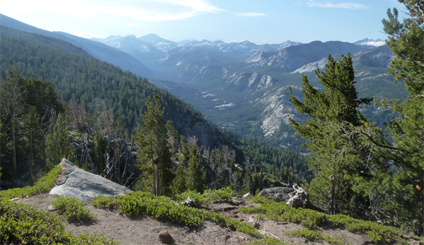
I continued through the woods on a level, relatively easy path before starting the long climb to Deer Meadow. I was enjoying the stretches of high mountain much more than the trekking below the treeline and found the next couple of hours to be a couple of hours too long. Eventually though the path breaks out of the greenery and zigzags its rocky way up to the first Palisade Lake. I had a welcome rest and lunch here. The way to the second Palisade Lake looks pretty level, bit of a snag though - the sides of the lake are too sheer to provide any possibility of walking round the lake and the path heads upwards to find the only route through (and down!) towards the lake.
It was hot and I was feeling tired, but I slogged up the path to Mather Pass and was astonished by the view on the other side. I forgot the slog up (cliche fashion) and gazed for ages at the wide, open valley spread out like a map pasted onto the land. There was a steep descent in front of me, beyond that was rocky high mountain terrain dotted with tarns, beyond that the 'bay' narrowed into a wooded valley, the trees like moss on a rock in the distance. Beyond even that were more mountains.It was a view you couldn't fit into the Uk - or even the Alps for that matter.
I descended to the upper basin and camped by the river. There were a few mossies determined to stop me getting a bath - so I made do with a sponge down in the tent. I did manage to cook up a good meal though.
Day 11
Headed down the valley into the woods again eventually arriving at the Woods Creek suspension bridge. I'd prepared lunch with my meal the previous night - so tucked into rice and fish near the campground. Some clever folks had fashioned a table and chairs from the rocks and fallen logs around the place - a rustic picnic spot.
I was soon gaining height again through the woods, on my way past some stunning lakes - Dollar Lake is just perfect, though camping there was prohibited when I arrived as the area was being given a chance to recover. This was not my goal though - I was aiming for Rae Lakes, which would give me a fast approach to Glen Pass the following morning. As I reached the first of the lakes I immediately camped - it was 6pm and I'd walked long enough.


Day 12
I was aiming to do two passes today - I reached Glen Pass easily in the morning and although there followed a long descent the route manages to stay relatively high, and above the treeline for most of the way. The route re-takes the high mountains quickly after starting the ascent to Forresters Pass. It took most of the day to reach Forresters and I met three young men on a scrambling trip at the top. The footprint of the pass is very small and the views spectacular - as be-fitting the highest pass yet gained - 13,000ft. There isn't a natural route down the other side of Forresters, just the well engineered zigzagging path that has been built onto the side of the mountain.
Far below the upper basin is dotted with tarns, and a large lake to the left. On a different timetable the guidebook takies you down to find some woods to camp in - on my timetable it was almost time to stop for the night - so I made my way across to the Lake outflow and camped on the soft grass. The area was mosquito free and I caught up on washing and cleaning me and my clothing - managed a good meal and hit the sack happy.
Day 13
Slept in today! Initial stages were downhill and Imade good progress. However on the next uphill section I struggled, I had climbed 9,300ft over the previous two days and it was catching up with me - I cooked up a large portion of Cous Cous for lunch and carried on - reaching Guitar Lake at around 3pm. This is the traditional camping spot for the ascent of Whitney and a long last day - and there were quite a few hikers there already. Its possible to go to the next lake which is a bit closer to the main event but I wasn't sure if there'd be a place to camp as it wasn't mentioned in my guidebook. I decided to stay where I was rather than risk going further and struggling to find a place for the night. There was enough area to camp in relative privacy. I was a day earlier than planned - so had been able to dip into a bit extra food along the way (having carried and extra days worth). I spent the rest of the afternoon admiring the scenery, washing and eating - ensuring I would have enough fuel for the following day.
Day 14
I set the alarm for 5.30 am and prepared everything for a fast getaway - I was aiming to leave by 6.00am, just as it was getting light. When I stepped out of the tent at 5.30 in the darkness, and gazed in the direction of Mt Whitney I was astonished to see a line of headlamps far in the distance! I managed to get packed up and away by my target time, and headed off. The initial route up the mountain zig zags to a trail junction where the JMT joins the Tourist route. Many people leave their gear here as this is also the route down. With virtually no food left my pack was pretty light anyway so I took it all the way to the top!
The route from the trail junction is quite spectacular, as it snakes across a rocky ridge section before reaching the Whitney Massif itself. After this its a straightforward walk to the top - and the JMT finish. I reached the summit at 9.20am.
After taking in the views I joined the other tourists and thru hikers on the long route down to Whitney Portal, 6,300 ft below. I finally reached the carpark at 4.30.


**In 2011 my understanding of the rules for camping were that you could camp anywhere except for designated recovery areas. A brief look at the current rules shows: You are asked to camp in an established campsite where others have camped before or on hard ground where you will leave no trace.
Route Summary
|
Further Information